COMPUTATION

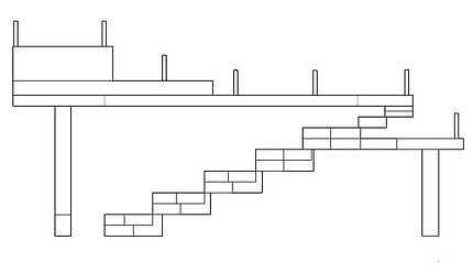
The Gorai Jetty, located at the northern edge of Borivali in suburban Mumbai, functions as a crucial ferry point across the Gorai Creek. It connects the mainland with Gorai Village, Manori Village, and other smaller island settlements. The site is nestled within a sensitive ecological setting — dense mangrove forests, marshlands, and tidal waters frame its edges, while fishing activities continue as a parallel livelihood.


The jetty accommodates a diverse group of commuters. Tourists frequently use the ferry to reach nearby attractions such as Water Kingdom, Essel World, and the Global Vipassana Pagoda, while workers travel daily with their two-wheelers — scooters and bikes — to access the mainland for employment. This dual use brings together pedestrians and vehicles in a compact, constantly shifting space.
The process of visiting and mapping the site was carried out collectively as a group, where we worked together to record physical features, measure dimensions, and chart the spatial relationships of the jetty within its ecological and urban context. The observations made during the visit were more personal and individual in nature.


LOW TIDE IMAGES HIGH TIDE IMAGES
.jpeg)


the relationship between its floating structure and the tidal nature of the creek. The jetty adjusts with the rise and fall of the tide, yet the surrounding ground conditions and approach levels do not. During high tide, water covers the lower edge of the jetty, effectively reducing the usable width and creating points where pedestrian and vehicular movement is restricted. This variation in levels compresses flows into narrower sections, producing zones of congestion and forcing constant negotiation between commuters on foot and those on two-wheelers.
The floating jetty accommodates tidal shifts vertically, but horizontally the shrinking ground-to-jetty span pushes back movement, redistributing people and vehicles unevenly across the space. In these moments, movement patterns become more alert and responsive. The pause created by these tidal restrictions cause the stretch of jetty that is used as a intermediate space of transport between the and ferry during the lower tides to disappear entirely while the edge merges along with the market space as well as the ferry docking point.